Maps have a scale which relates the distance on the map to the corresponding distance on
the ground. For example, on some ordnance survey maps the scale 1 : 50 000 is quoted
on the cover. This means that a distance of
Worked Examples
The map shown below has been drawn with a scale of 1 : 50 000. (There may be variations in distances on the diagram, due to printing.)
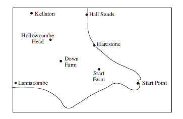
Find the distances between:
Give your answer in kilometres.
As the scale is 1 : 50 000 , each centimetre on the map represents 50 000 cm in reality.
Down Farm and Start Farm,

From the map the distance between Down Farm and Start Farm can be measured as 2.4 cm.
The actual distance between the two points is given by:
| 2.4 × 50 000 | = 120 000 cm |
| = 1200 m | |
| = 1.2 km |
Kellaton and Harestone.
The distance between Kellaton and Harestone can be measured as 4.3 cm.
The actual distance can then be calculated:
| 4.3 × 50 000 | = 215 000 cm |
| = 2150 m | |
| = 2.15 km |
The distance between two places is 12 km. A map scale is 1 : 25 000. Find the distance between the two places on the map, in centimetres.
This map will use 1 cm for every 25 000 cm in reality.
First convert 12 km to centimetres.
| 12 km | = 12 000 m |
| = 1 200 000 cm |
To find the distance on the map divide 1 200 000 by 25 000. This gives
= 48
So on the map the two places will be 48 cm apart.
Two places are 4.5 km apart. On a map they are 15 cm apart. What is the scale of the map?
First convert 4.5 km to cm, so that both distances are given in the same units.
| 4.5 km | = 4500 m |
| = 450 000 cm |
The scale can then be expressed as the ratio
15 : 450 000
because 15 cm on the map represents 450 000 cm in reality. This ratio can be simplified by dividing both numbers by 15 to give
1 : 30 000
Exercises
