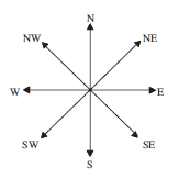
When describing a direction, the points of a compass can be useful, e.g. S (south) or SW (south west).
A bearing can also be used, often in navigation and by people walking on rough or open moorland or hills.
Note
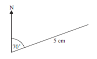
Bearings are always measured clockwise from north and use 3 digits.
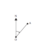
The bearing of A from O is 050° .
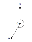
The bearing of A from O is 210° .
Worked Examples
On a map of Kenya, find the bearings of
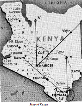
Wajir from Nairobi

First draw in a north line at Nairobi and another line from Nairobi to Wajir.
Then measure the angle clockwise from north to the second line. In this case the angle is 47° so the bearing is 047°.
Makindu from Mombasa.
Draw a north line at Mombassa and a line from Mombassa to Makindu. The bearing can then be measured as 312°.
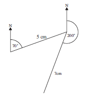
A boat sails for 500 miles on a bearing of 070° and then sails a further 700 nautical miles on a bearing of 200° . Find the distance of the boat from its starting point and the bearing that would have taken it straight there.
To find the solution use a scale drawing.
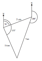
It is 5.4 cm, which represents 540 nautical miles.
A ship leaves port P and sails to port Q on a bearing of 124°. From Q, the ship travels to port R on a bearing of 320°.
Given that the bearing of R from P is 025° :
Draw a carefully labelled diagram to represent the journey of the ship.

Determine the bearing of P from R.
Bearing of P from R is
180° + 025° = 205°
Bearings are used again in section 4 of Unit 34, when you calculate distances between points.
Exercises

Investigation
Draw a rectangle of any size. Use your ruler to locate the mid-points of the sides. Join these mid-points to form a new quadrilateral.
What is the name of the quadrilateral you have obtained?
Repeat the above by drawing
(a) a trapezium
(b) a parallelogram
(c) a kite
(d) a rhombus
(e) a quadrilateral of 4 unequal lengths.
What conclusion can you draw from these?